Showing posts with label Technology. Show all posts

Thursday, 18 June 2015

NASA harnesses space technology to find victims of natural disasters


While Google recently made news with a patent filing for drones that could provide emergency medical services, NASA has long been finding ways to take their innovative space-bound technology find a way to apply it to everyday life on Earth.

Most recently, NASA is taking their advances designed to explore the likes of Jupiter and Saturn and apply it directly to saving lives.

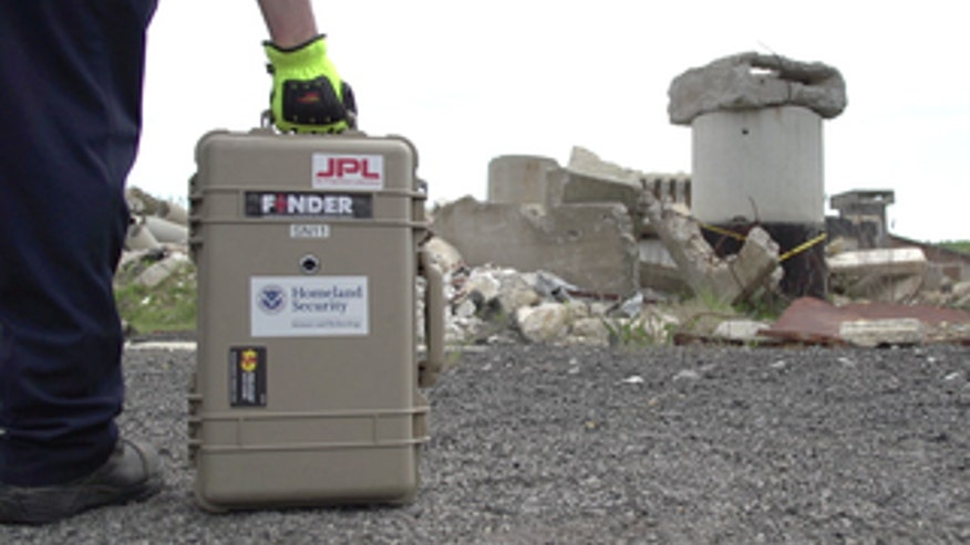
The NASA Jet Propulsion Lab team worked with the Department of Homeland Security to develop a version of this space exploration system to rescue humans in disasters. The cutting-edge Finding Individuals for Disaster and Emergency Response (FINDER) technology recently saved four lives in during a collapse of a textile factory and another building in village of Chautara in Nepal.

What exactly is FINDER? It is a portable, lightweight, 20-pound radar detector that is about the size of an average suitcase. The detector is ideal for finding people trapped under debris from natural disasters like avalanches, earthquakes, and wildfires. The sooner a victim can be located, the sooner they can be rescued and receive medical care. The time it takes to find them can mean the difference between life and death.

How does it work?

FINDER locates people by sending out a low-powered microwave signal through the rubble. The signal is about a mere one-thousandth of a typical smartphone's output.

It then looks for changes in the reflections of those signals that reverberate back to the device. These changes are caused by the tiny movements a person may make.

In fact, when NASA tested FINDER, the detector could pinpoint a person’s heartbeat buried beneath a whopping 20 feet of solid concrete. It could also detect a heartbeat beneath 30 feet of rubble.

To systematically sweep a disaster zone, rescue teams can take a laptop and run the FINDER software. They can program this tech to scan a specific. It then analyzes the microwaves that bounce back.

FINDER seeks out typical human motions like the chest rising and falling while breathing. The program alerts the rescuers to where the signal is strongest to help narrow down the location. It is even so precise that is can differentiate between the heartbeats of a human and those of an animal.

NASA built four new FINDER prototypes in just one year. These prototypes underwent extensive testing by first responder teams in seven states — California, Florida, Georgia, Indiana, New Jersey, Oklahoma, and Virginia.

NASA engineers brought FINDER to search and rescue teams to test how the tech would perform in a range of disaster scenarios.

Saving lives

FINDER got to prove what it could do in its rescue of the four men in Chautara, which was impacted by the 7.8-magnitude earthquake that struck Nepal in April. The men were trapped under approximately 10 feet of debris like brick wood and mud. This was the first time that this detection technology was used in an actual disaster.

“The true test of any technology is how well it works in a real-life operational setting,” aid Reginald Brothers, Department of Homeland Security’s under secretary for science and technology, in a release. Of course, no one wants disasters to occur, but tools like this are designed to help when our worst nightmares do happen. I am proud that we were able to provide the tools to help rescue these four men.”

NASA sees a lot of potential for FINDER, with the possibility for it to be applied to augment drone deployment to locate victims to even monitoring — from a safe distance — contagious patients who are kept in quarantine.

Thursday 17 June 2015

http://www.foxnews.com/tech/2015/06/17/nasa-takes-space-technology-to-detect-victims-natural-disasters/

continue reading

Tuesday, 20 January 2015

Handheld Biometrics Deployed To Indonesia In Aid of AirAsia Victim Identification


AirAsia Flight QZ8501 went missing on December 28, 2014, enroute from Surabaya, Indonesia, to Singapore. The fight was found shortly after, having crashed into the waters south of Borneo and killed all 162 passengers.

In the effort to identify the fallen victims of this latest major airline disaster, Indonesia’s Automatic Fingerprint Identification System (INAFIS) has been employed with the various Disaster Victim Identification teams. Using a number of technologies including the Trident handheld reader from Credence ID – which is using the Mobile Automatic Multi-Biometric Identification System (MAMBIS) – the disaster response teams are hoping to match the victims’ traits with photos, names and addresses.

According to law enforcement officials from Indonesia, MAMBIS can produce 100 percent matches on victims whose fingerprints have not been damaged, while offering 60 percent accuracy with damaged samples. Over 50 percent of the AirAsia victims have been identified using the Trident device, bringing peace of mind to the mourning families affected by the disaster. Those victims who require other methods of identification, such as X-Ray or DNA matching, will take a significantly longer time to positively match to records.

Underneath the tragedy and ensuing investigation efforts related to the AirAsia crash is the thankful fact that Indonesia benefits from an extremely comprehensive national ID database that includes the biographic and biometric data of nearly every one of the country’s 250 million plus citizens. A national registry, in tragic times like this, is helping identify bodies at a very fast pace thanks to mobile biometric readers like the Trident.

The Trident handheld device, which can enroll and match face, fingerprint and iris biometrics, is used all around the world. In August, Credence ID announced that it won contracts in Mexico and Guatemala to aid in managing the identities of prison populations.

Tuesday 20 January 2015

http://mobileidworld.com/biometrics-deployed-to-indonesia-in-aid-of-airasia-victim-identification-1193/

continue reading

Friday, 18 October 2013

More mobile phones mean fewer deaths from natural disasters


Fewer people were killed or affected by natural disasters than in any other year in the past decade, according to a report (pdf) released Oct. 17. In 2012, some 15,706 died, compared to 37,907 in 2011 or almost 304,474 casualties in 2010, according to the International Federation of Red Cross, IFRC, and Red Crescent Societies.

The smaller death toll is in part because last year didn’t see brutal disasters like the 2004 Indian Ocean tsunami that left over 230,000 dead in South and Southeast Asia, Cyclone Nargis in Myanmar in 2008, or the 2010 earthquake in Haiti, each of which killed over 100,000. But we can also thank cell phones for last year’s smaller disaster-related death toll, according to the IFRC report.

In the Philippines, for example, which is struck by about 20 typhoons a year and whose population is scattered over thousands of archipelagos, mobile phones have been especially helpful. (Today, the number of cell phone subscriptions outnumber people.) The country has set up a surveillance system to send disaster damage reports and other data to emergency health officials via text messages. Before Typhoon Bopha—a category 5 super typhoon with winds of 280 km/h (175 mph) landed last year, authorities were able to evacuate some 41,000 citizens as well as quickly rescue people after the storm struck, thanks to cell phones and other communication technology. Even though Bopha was the most powerful storm the country had experienced up to that point, its death toll is behind that of eight other storms that hit before 2012. So far this year, 11 people have been killed during the worst typhoon of the year.

The idea of “humanitarian technology” has been picking up steam over the past few years. There are 6.8 billion mobile phone subscribers in the world. And if proper planning is in place cell phones in particular could be one of the most effective means for authorities and rescue staff to communicate with the public during emergencies and natural disasters. (One caveat is that after disasters hit, communication infrastructure, including cell phone towers, is often knocked out of service.) Earlier this month, mobile phones helped relief workers in India coordinate one of the country’s largest evacuation efforts ever and helped citizens dodge the worst of Cyclone Phailin.

There’s room for more use of mobile phones in rural areas where people traditionally get their news from their neighbours and relatives. As more people in rural regions as well as in developing countries subscribe to cheap cell plans, they can get disaster and safety information directly and quickly. Moreover, locals—in both rural and urban areas—are usually responsible for the bulk of the rescue efforts during the first critical hours after a natural disaster. These de facto first responders would be further helped with phones that help them reach or consult with health workers and aid agencies.

Friday 18 October 2013

http://qz.com/136684/more-mobile-phones-mean-fewer-deaths-from-natural-disasters/

continue reading

Wednesday, 18 September 2013

SimCity's Red Cross charity pack aids real-world disaster victims


SimCity fans know nothing feels better than saving their other family from pollution and sickness -- except, you know, helping out some fellow human beings. A new collaboration with the Red Cross combines players' digital altruism with humanitarian aid for real-world disaster victims. Starting today, you'll be able to purchase a $9.99 "charity pack" created specifically for the game, with a relief center, tents and two emergency response vehicles. In the event of a meteor strike, earthquake or tornado, the Red Cross tents will automatically appear to provide aid for injured Sims, and a fleet of ambulances and fire trucks will be on call as well.

SimCity creator EA Games has pledged to contribute at least 80 percent of profits (a minimum of $100,000) from the charity pack to the Red Cross National Societies. The set will be available for a year, and you'll be able to keep it through the life of your current game. Currently, the pack is only available for players in 10 countries, including Denmark, France, the US and the UK.

Wednesday 18 september 2013

http://www.engadget.com/2013/09/17/simcity-red-cross-charity-pack/

continue reading

Thursday, 5 September 2013

YouTube Preroll helps find missing persons for Aussie Police


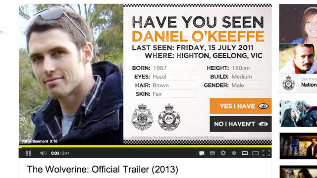
There are 1,600 missing persons cold cases in Australia. To help families find their loved ones, the Australian Federal Police and agency VML took to YouTube with the "The Missing Persons Pre-Roll."

During Missing Persons Week, YouTube showed photos and stats about each missing person. These were location-specific, targeting YouTube viewers who lived close to where the missing individual was last seen.

To spread awareness about Missing Persons in the country, instead of the "skip ad" button, viewers were given the chance to click "Yes, I have" or "No, I haven’t" seen the missing individual. so people were forced to think a little before they clicked.

The ads used geo-location targeting to show persons that were missing near you. The ads got 1.2 million views over five days.

Best of all, Two hundred and thirty-eight people clicked "yes," and were taken to a page where they could update the cold case file and help provide police with leads.

Click on the link below the pre-ad to view

The Missing Person Pre-Roll from VML on Vimeo.


Thursday 5 August 2013

http://adage.com/article/creativity-pick-of-the-day/youtube-preroll-helps-find-missing-persons-aussie-police/243958/

continue reading

Saturday, 31 August 2013

3D maps created in real time could aid disaster search and rescue


Highly detailed 3D maps of indoor and outdoor environments can now been created in real time with no drift thanks to a new mapping algorithm. The maps could be created in the immediate aftermath of a disaster to help search and rescue teams navigate and understand hazardous or unknown environments.

Researchers from MIT and the National University of Ireland used a low-cost Kinect camera to test the algorithm by filming environments and creating richly detailed 3D maps as they went. The camera recognises locations it's seen before and so when it returns to its starting point it forms a closed loop and stitches the images together.

Some of the scenarios in which this technology could be used in include "architecture and surveying-type operations, autonomous robotics settings and disaster management scenarios," Thomas Whelan, a PhD student at NUI, tells Wired.co.uk. "For example, areas of a building could be scanned in real-time by an architect to quickly design, visualise, and evaluate a renovation project. Or, a human operator could scan in parts of a building during a disaster scenario to evaluate the damage after an earthquake."

3D mapping is nothing new, but it has long suffered from a phenomenon known as "drift", which adds up all the small errors in the estimated path taken to create a disjointed map. To generate accurate maps, you have to know which of the millions of points need aligning. In the past this has been tackled by running the data over and over, but this isn't a practical approach to making maps in real time.

"Being able to map in real-time has a number of significant advantages, such as being able to perform decision making regarding the mapped area as it is being explored, which again is important for autonomous robotics and search and rescue type situations," says Whelan.

The new algorithm, however, keeps track of the camera's pose and positioning throughout its journey so that when it returns to the start point, it knows which adjustments to make. A Kinect camera takes images at 30 frames per second, which allows the algorithm to measure the camera's movements between each frame. It can then fix the points where walls and stairways don't meet and untangle the warped pathways, manipulating them so they accurately represent the space they've moved through.

"The density and fidelity of the maps enables the use of advanced object detection and semantic analysis techniques, providing very high level information about the area explored."

Maps of various indoor and outdoor locations in London, Sydney, Germany and Ireland, as well as in MIT itself, have been created using the technique. The team have made a video demonstrating the method which show maps being created and twisted into shape in real time.

The most exciting part of the work is probably the idea that autonomous robots could use the technology to help them make decisions about which direction to travel in and gain a deeper understanding of their environments, but it has the potential to be used in all sorts of situations.

"I have this dream of making a complete model of all of MIT," says Whelan's colleague John Leonard, a professor of mechanical engineering at MIT. "With this 3D map, a potential applicant for the freshman class could sort of 'swim' through MIT like it's a big aquarium. There's still more work to do, but I think it's doable."

Saturday 31 August 2013

http://www.wired.co.uk/news/archive/2013-08/30/real-time-3d-mapping

continue reading

Saturday, 19 May 2012

Abertay University student's system uses digital networks to plot real-world disasters

The way emergency crews search for missing people following a natural disaster could be revolutionised by the work of a Dundee student. David Kane, a computing and networks student at Abertay University, has developed a programme whereby broadband routers are used to detect whether a building is still standing. By ''pinging'' internet addresses in areas affected by disasters such as tsunamis and hurricanes, David's software could provide information to assist rescue teams, detailing the extent of the disaster and the areas worst hit. David, whose work has been exhibited at the university's degree show, said: ''Responding to disasters is immensely difficult and any extra accurate information can make the difference in saving lives. ''I wanted to prove it was possible to use an ordinary piece of technology we all have, a home broadband router, to map natural disasters in real-time.'' Using Google Maps, the system shows live data from ''safe'' areas from which signals have been received from routers. It could be assumed that areas from which no signal is returned have been worse hit, allowing rescue crews to focus their efforts on saving lives there. ''The idea definitely works and I've built it so anyone can take this code and improve it,'' he added. Saturday 19 May 2012 http://www.thecourier.co.uk/Living/Digital/article/22808/abertay-university-student-s-system-uses-digital-networks-to-plot-real-world-disasters.html

continue reading