
It was 10 minutes past midnight of August 17, 1976, a Tuesday.
While most people were sleeping, a massive earthquake, registering magnitude 8.0 on the Richter scale, rocked most of Mindanao and parts of the Visayas.
The tremor was most strongly felt in the cities and towns surrounding the Moro Gulf, particularly in Cotabato City, which now hosts the regional center of the Autonomous Region in Muslim Mindanao (ARMM).
What made the 1976 Moro Gulf Quake most devastating, however, was not just the degree of the earth shaking.
With its epicenter near the town of Lebak in Sultan Kudarat, in a region of the Celebes Sea where earthquakes frequently occur – the 1976 Moro Gulf quake brought with it one of the most terrifying natural forces known to man: a tsunami.
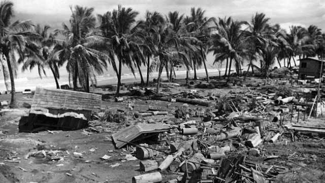
Without warning, about 2-5 minutes after the earthquake struck, waves as high as 9 meters reached the shore and inundated communities along the Moro Gulf.
The tsunami affected 700 kilometers of coastline, with Pagadian City, Cotabato City, Zamboanga City, and Lebak in Sultan Kudarat experiencing the highest waves.
About 8,000 people died, including those missing and were never found, making it the most disastrous tsunami to hit the Philippines.
It is more than the number of casualties recorded after Super Typhoon Yolanda, the strongest typhoon in the world, hit the country.
Midnight killer
Philippine Institute of Volcanology and Seismology (Phivolcs) director Renato Solidum said the high number of deaths – many of whom were children – could be attributed to the time the tsunami struck and the number of people residing near the shore at that time.
"Many people lived near the coast. Also, it was very dark. [It was] past midnight… Why many [died]? It's because it was sudden. If it happened in the morning when children are in school, a lot of people would probably be able to run for their lives," Solidum explained.
It’s important to note the type of the tsunami, he added. "It was a local tsunami. The onset of the first event (wave) occurred 2 to 5 minutes after the earthquake. Definitely, the height of the wave would matter in terms of the number of deaths."
While the earthquake caused fire and some buildings to collapse, the tsunami caused most of the damage.
The massive devastation brought by the Moro Gulf earthquake and the tsunami that followed resulted in a change in the country's disaster preparedness plans. It also led then president Ferdinand Marcos to revise the provisions of the National Building Code a year after the tragedy.
In 1978, Marcos created the National Disaster Coordinating Council, the predecessor of what is now known as the National Disaster Risk Reduction and Management Council.
Tsunami generators in PH
The Philippines is more vulnerable to geological hazards such as earthquakes and tsunamis, according to the Phivolcs, due to its geography as an archipelago located along the Pacific Ocean's Ring of Fire.
Located along every side of the Philippine archipelago are different trenches that can generate tsunamis should the trenches move enough to create an earthquake.
According to Solidum, tsunamis in the Philippines are more dangerous compared to those that occur in other countries such as Indonesia and Japan.
“The tsunamis in our country arrive much faster than those in Indonesia and Japan because the source of the earthquake or the trenches are closer to the shorelines. If the trenches are closer to the shoreline, then the source of the tsunami will be much closer to the shoreline, so the distance will only be short and the lead time will be shorter,” he explained.
While chances of tsunamis are higher in large bodies of water, inland seas like in Bohol and Cebu can also generate tsunamis and landslides.
In Metro Manila, which lies near the Manila Trench and beside Manila Bay, a magnitude 6.5 earthquake can generate a tsunami as high as 4 meters, which could kill about 3,100 people. This is based on the 2004 Metro Manila Earthquake Impact Reduction Study conducted by the Japan International Cooperation Agency.
Communities need to be prepared
In 2004, more than 200,000 people died after an earthquake and tsunami struck off the Sumatra Coast near Banda Aceh, Indonesia, where more than half of the casualties came. The tragedy painfully highlighted the need for reliable tsunami early-warning systems along coastal areas.
Following the devastating 2004 Indian Ocean earthquake, Phivolcs developed a tsunami detection system by setting up dry and wet sensors in 10 sites all over the Philippines.
The agency also produced tsunami hazard maps for coastal areas.
Phivolcs has also set up 19 tide gauges to warn communities of a coming tsunami. “The sensors are to confirm if the earthquake did or did not generate a tsunami. Or if there is a tsunami, the sensors will also be used to tell us if the tsunami waves are over,” Solidum said.
But Solidum emphasizes that the agency can only do so much. While the Phivolcs is ready to monitor and give warnings, nothing can compare to the vigilance and readiness of local communities.
“The issue here is how people will respond. Remember, it’s a local tsunami event - we cannot beat the two minutes," Solidum said.
Solidum adds that the 1976 Moro Gulf tsunami serves as a lesson for local communites to prepare for any disaster.
“It is a very good example of a threat of a sudden onset of an event after an earthquake that people need to know... People need to know which areas will be affected, where they will go if they will be evacuated and where the safe evacuation centers should be located.”
Tuesday 18 August 2015
http://www.rappler.com/move-ph/issues/disasters/102827-1976-moro-gulf-earthquake-tsunami


0 comments:
Post a Comment