
In the waning days of April 2014, two months after Malaysia Airlines Flight 370 disappeared somewhere near the South China Sea, 60-year-old American pilot Michael Hoebel reported that he had found it. Unlike many searchers, Hoebel was not employed by a government, or an airline; he claimed he had discovered the wreckage of the passenger jet from the comfort of his home computer. He was not alone: About 8 million other people logged onto the global-imaging crowdsource website Tomnod during the initial, frenzied search for Flight 370.
It was not the site's first crowdsourcing campaign, but it was by far its most popular. Tomnod, a project of the geospatial content company DigitalGlobe, provided armchair plane-hunters like Hoebel with constantly updated satellite images of the rapidly growing search area and the tools to digitally “tag” mysterious shapes in the sea. More essentially, it gave people the world over a way to feel like they were really helping to find the plane. They didn't, really: Hoebel’s “plane," off the coast of Thailand, wasn't a plane at all. Flight 370 is still missing, over a year after it fell off of radar.
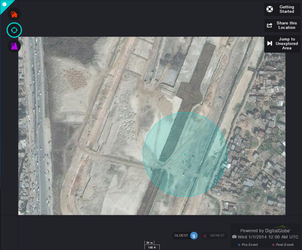
But the amateur satellite-image-perusers are still at it, and Kevin Bullock, director of product management at DigitalGlobe, says this current Tomnod campaign may be more important. Last Saturday night, a 7.8 magnitude earthquake hit near Kathmandu, the capital and largest city in Nepal. By Sunday morning, DigitalGlobe's satellite had captured images of the destruction in the city and its surrounding villages and had uploaded them online—nearly 5,700 square miles in all.

Since then, over 16,500 volunteers have used the Tomnod platform to compare the new satellite images with the old, placing 74,000 tags on major destruction areas, damaged roads, and ravaged homes. Their crowdsourced data is plugged into an algorithm that identifies frequent tag agreements to discover which areas are in need of the most help. That information is then made available to relief groups, who can use the images to target survivors in need of food, water, tents, and medical supplies.
“What’s interesting to me is that that Malaysian Flight 370 grabbed the world’s headlines, but it’s a needle in a haystack situation. We haven't found the plane,” Bullock said in a phone interview. “There’s a stark difference with Kathmandu. …Here we are actually helping to save lives. We can really show [where help is needed] with coordinates.”
The Tomnod community—DigitalGlobal says about 1 million people are registered users of the site—hasn't quite taken to the challenge of mapping post-earthquake Nepal like it did to the mystery of the plane. (The Nepal campaign has seen just 0.2 percent of the total volunteers of the Flight 370 campaign, though it's still too early for a final engagement tally.) Still, amateur mappers have congregated around the campaign's social media sites to share tips and tricks.
As with much amateur online work, parts of the Tomnod campaign feel frustratingly ineffectual—a little bit like a way for people with all the privileges of internet access to feel good about doing little. As CityLab pointed out Monday, professional mappers are already volunteering to map Nepal’s devastated areas through the open-source mapping platform OpenStreetMap, where their more sophisticated skill sets give them a better chance to help humanitarians on the ground, and more quickly. (While Tomnod's data helps groups pinpoint problem areas, Bullock explains, the OSM data will actually allow them to navigate Nepal's altered topography to get there.)
But Tomnod’s strength is simplicity. While OSM’s more advanced software is less accessible to the lay Internet user, the crowdsourced campaign can be used by anyone. “I have a 9-year-old daughter, and she can do this,” Bullock says. “Anyone can do this. …. You can pull out your phone and just spend five minutes contributing to the cause.”
There's another benefit. Over 4,600 bodies have been pulled from the rubble in Nepal, and that number will certainly rise. But statistics and photos of disaster in faraway lands are a dime a dozen, and empathy doesn't come cheap. In other words: Getting those in wealthy countries to donate is not an easy task. But there's something devastatingly unique and striking about Tomnod's grainy pictures of destruction from above. You'll toggle through before and after pictures to find that a road or a cluster of homes is just gone.
Wednesday 29 April 2015
http://www.citylab.com/tech/2015/04/how-amateur-mappers-are-helping-recovery-efforts-in-nepal/391703/


0 comments:
Post a Comment